The French & Indian War
The Ohio River Valley & The Message that Changed Everything
Washington and his troops had been sent by Virginia’s Colonial Governor, Robert Dinwiddie, to remove the French from the forts they had established along the Ohio River beginning in 1753. The British believed that the Ohio Country, as it was called, was rightly theirs as an extension of the Virginia Colony. The French on the other hand believed that it was theirs by right-of-discovery.
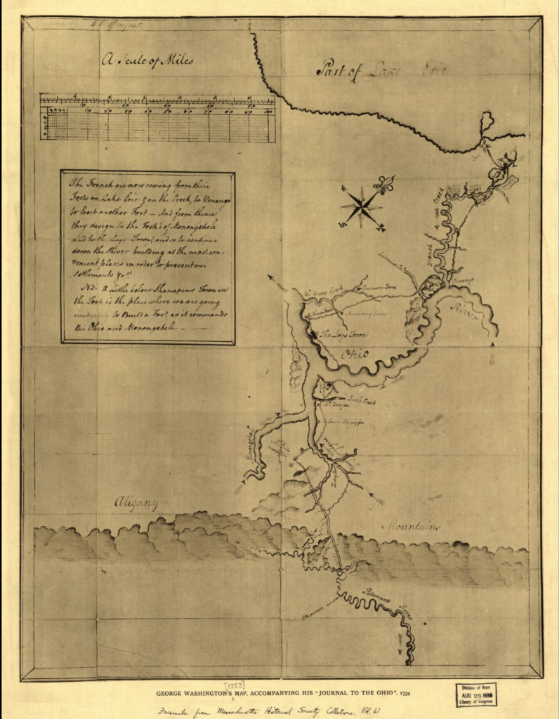
This particular precursor to the French & Indian War is well documented, but it’s an important part in understanding Washington’s journey from surveyor to patriot. In 1753, Washington was only 21-years-old and serving as a Major in the Virginia Militia when he received orders from Virginia’s Governor Robert Dinwiddie to deliver a letter to the Commandant of the French troops. In his commission written to Washington on October 30, 1753, Dinwiddie says,
“I reposing especial Trust & Confidence in the Ability Conduct, & Fidelity, of You the said George Washington have appointed You my express Messenger, And You are hereby authoriz’d & impower’d to proceed hence with all convenient & possible Dispatch, to that Part, or Place, on the River Ohio, where the French have lately erected a Fort, or Forts, or where the Commandant of the French Forces resides, in order to deliver my Letter & Message to Him; & after waiting not exceeding one Week for an Answer, You are to take Your Leave & return immediately back.”
Commission from Robert Dinwiddie, 30 October 17532
You can read the complete instructions from Dinwiddie to Washington here.
The French had just built Fort LeBoeuf in the Ohio River Valley, and, simply put, the British wanted them to leave the Virginia territory and head back north toward Canada. In his letter to the French Commander, Dinwiddie states plainly,
The Lands upon the River Ohio, in the Western Parts of the Colony of Virginia, are so notoriously known to be the Property of the Crown of Great Britain, that it is a Matter of equal Concern and Surprize to me, to hear that a Body of French Forces are erecting Fortresses, and making Settlements upon that River, within his Majesty’s Dominions.
However Sir, in Obedience to my Instructions, it becomes my Duty to require your peaceable Departure; and that you would forbear prosecuting a Purpose to interruptive of the Harmony and good Understanding, which his Majesty is desirous to continue and cultivate with the most Christian King.
You can read the complete The Journal of Major George Washington (1754) here, which includes Governor Dinwiddie’s letter, Washington’s journal entries, and the French Commandant’s response to the British request to leave the Ohio River Valley.
| The French, The British, & The Concept of Discovery In the 1700s, the British and the French had very different definitions of settlement. The French focused on expanding their industry, not necessarily in settling and colonizing new territories. They claimed Canada, Newfoundland, Labrador, St Lawrence, & Acadia, growing their fishing operations and establishing trade alliances with American Indians. On the other hand, the British believed in discovery and settlement via colonization. The British colonies looked very different from what we know today. Virginia in the 1750s spanned to the Great Lakes, through the Ohio River Valley, so when the French kept creeping further and further south, claiming more and more land in the process, the British were unimpressed, to say the least. This bold move from the French led to Governor Dinwiddie sending 21-year-old Major George Washington to the Ohio Valley in October 1753. The French interest in the Ohio Country lay in its strategic location as a passage between its settlements in Canada and those in the Mississippi Valley which had grown in the early 18th century and were linked economically with its Colony in Louisiana. The French also saw the linkage of these areas as a barrier to the westward expansion of the British from their colonies east of the Appalachian Mountains. The British, on the other hand, were faced with a growing population in their colonies with limited prospects for westward expansion beyond the Appalachians due to the French and Indian presence in the Ohio and Mississippi river valleys. The British felt it was imperative to prevent the French from gaining control over these western river valleys. The competition between the French and British trading alliances coupled with their divergent territorial interests would inevitably lead to conflict. In August of 1753 the British cabinet instructed all colonial governors to prevent any efforts by the French to encroach on the frontiers of the British colonies and to erect forts in the King’s territories.3 |
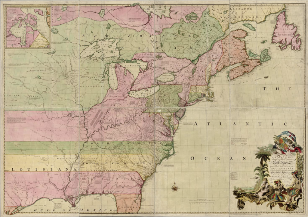
| Pause to explore! The Library of Congress has a map from 1755 that shows the territories in North America very clearly. |
Jumonville Glen

| Want to learn more about Jumonville Glen? The National Park Service (NPS) has an audio clip from their self-guided tour. The American Battlefield Trust has an essay on the skirmish. The Smithsonian Magazine wrote an article called, When Young George Washington Started a War. Dr. Carl Ekberg wrote a piece called, Washington, Gist, & Half-King Start a World War in the French & Indian War Foundation’s Volume 15, Issue 4 Newsletter from Fall 2020. Mount Vernon has an essay on the Jumonville Glen Skirmish. |
But why did it start?
A spark lit in 1754 would eventually result in a worldwide conflict when the Virginia Colony dispatched Captain William Trent with a small company of Virginia militia to build a fort at the Forks of the Ohio at present day Pittsburgh, Pennsylvania.7
While the British were building a fort on the Ohio, the French ordered the commander of their force in the Ohio Country to move his command from Fort LeBoeuf, built in 1753 near Lake Erie at present-day Waterford, Pennsylvania, down to the Forks. The orders included instructions to construct the final fort that would secure the Ohio valley for them. The French moved quickly in the Spring of 1754 and captured the incomplete British fort at the site. They then began construction of their own strong fort to be named Fort Duquesne after the then Governor-General of New France.

At the same time Governor Dinwiddie sent the militia company to the Forks to build a fort, he also ordered the raising of a force to be sent to the Forks to defend Virginia’s interests. Twenty-two-year-old George Washington, now promoted to Lieutenant Colonel, would be second in command of the Virginia Regiment on the mission.9
While on route to the Forks, Colonel Joshua Fry, commander of the regiment, died in an accident. Washington was then promoted to Colonel and given command of the expedition. On May 27, 1754, while encamped at Great Meadows, near present day Farmington, PA, Washington received word that a French party was heading in his direction. Alarmed by the news, Washington set off that night, in the rain, with forty-seven men. Near daybreak they met with Indian allies at the glen and attacked the French at Jumonville Glen, as described above.10
| The First World War The French & Indian War stemmed from the turbulent politics of 17th and 18th century Europe, which was characterized by a series of wars based on dynastic disputes. The war between Britain and France, known as the Seven Years’ War in Europe, was different in that it was about control of territory rather than dynastic dominance. The war was fought on four continents, Europe, North America, Asia and Africa. The first shots of this war were fired not in Europe, but on British America’s western frontier in the Pennsylvania backcountry.11 Because of the breadth of the Seven Years’ War, Winston Churchill referenced it as “the first world war” in his book, A History of the English-Speaking Peoples. Prior to the events at Jumonville Glen, eastern North America was contested by the Iroquois Confederacy, the British and the French. European colonists began trading with the Iroquois in the 17th century exchanging muskets for pelts making Iroquois warriors the most feared in eastern North America. Trading became competitive and inevitably led to conflict. Several wars ensued in the early 18th century before the outbreak of the large-scale war that we know today as the French & Indian War. |
Fort Necessity in a Nutshell
“The debacle at Fort Necessity in July 1754 is one of most compulsively studied episodes in George Washington’s life, for it was his elementary school in frontier warfare; defeat is a harsher but better schoolmaster than victory.”
Dr. Carl Ekberg
For more on Washington’s humiliation by Louis Coulon de Villiers at Fort Necessity, see Dr. Ekberg’s essay, George Washington’s Luckiest Day.
| Further Reading National Park Service’s Battle of Fort Necessity (essay) National Park Service’s Fort Necessity National Battlefield (video) A Charming Field for an Encounter (e-book) |
Braddock’s Defeat at the Battle of the Monongahela

We need to talk about one more French & Indian War story before we head to Fort Loudoun in Winchester, Virginia.
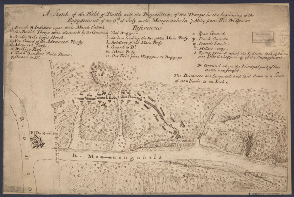
Following Washington’s defeat at Fort Necessity, the British sent an army of 5,000 men to Virginia under the command of General Edward Braddock in 1755 to capture Fort Duquesne and remove the French from the Ohio Country. Unfortunately, this expedition ended in disaster with two-thirds of the command lost to the French and their Indian allies at the Battle of the Monongahela on July 9, 1755.13
Washington, serving as aide-de-camp to Braddock on the expedition and one of the few surviving officers, led the retreat. Braddock himself was mortally wounded in the battle.
The defeat of Braddock’s army left the western frontier unprotected and prompted the Virginia Colony to form the Virginia Regiment to be comprised of 10 companies of 100 men each with the responsibility of defending the frontier from the Potomac R. to the North Carolina border 8 . George Washington was appointed Colonel in command of the regiment, a position he held from 1756 through 1758 when the war on the western frontier ended.
The events in North America led to a formal declaration of war by the British in 1756 resulting in the onset of the Seven Years War and the French and Indian War in North America. As it turns out Washington’s actions at Jumonville Glen changed the course of world history and resulted in Britain becoming the predominant naval power in the world and a pre-eminent colonial world power.
| Further Reading Ben Franklin’s World Podcast | Episode 060: David Preston, Braddock’s Defeat: The Battle of the Monongahela (podcast) French & Indian War Foundation Newsletter | Volume 7, Issue 1, February 2012 | Braddock’s Road, The Final Thrust: Fort Cumberland to the Monongahela, written by Norman Baker (book excerpt) Mount Vernon’s Interview with David Preston (transcribed interview) Braddock’s Road: Mapping the British Expedition from Alexandria to the Monongahela by Norman Baker (book) |
- Washington, G. (1754) George Washington’s map, accompanying his “journal to the Ohio”. [Boston] [Map] Retrieved from the Library of Congress, https://www.loc.gov/item/99446116/. ↩︎
- “Commission from Robert Dinwiddie, 30 October 1753,” Founders Online, National Archives, https://founders.archives.gov/documents/Washington/02-01-02-0028. [Original source: The Papers of George Washington, Colonial Series, vol. 1, 7 July 1748 – 14 August 1755, ed. W. W. Abbot. Charlottesville: University Press of Virginia, 1983, pp. 56–60.] ↩︎
- Mitchell, J., Kitchin, T. & Millar, A. (1755) A map of the British and French dominions in North America, with the roads, distances, limits, and extent of the settlements, humbly inscribed to the Right Honourable the Earl of Halifax, and the other Right Honourable the Lords Commissioners for Trade & Plantations. [London; Sold by And: Millar] [Map] Retrieved from the Library of Congress, https://www.loc.gov/item/74693173/. ↩︎
- Cross, D. (2020b, August 24). A Snapshot of George Washington EP. 9: More than a Messenger. YouTube. https://youtu.be/dn-BE31RBk4?si=d1AkNsNzRuE3lP1m ↩︎
- The Miriam and Ira D. Wallach Division of Art, Prints and Photographs: Print Collection, The New York Public Library. (1859). Death of Jumonville Retrieved from https://digitalcollections.nypl.org/items/58f3ab90-2e68-0133-bc04-58d385a7b928 ↩︎
- Anderson, F. (2001). Crucible of War: The Seven Years’ War and the Fate of Empire in British North America, 1754-1766. Random House. ↩︎
- Anderson, F. (2001). Crucible of War: The Seven Years’ War and the Fate of Empire in British North America, 1754-1766. Random House. ↩︎
- The Miriam and Ira D. Wallach Division of Art, Prints and Photographs: Print Collection, The New York Public Library. (1751 – 1885).Robert Dinwiddie, governor of Virginia. Retrieved from https://digitalcollections.nypl.org/items/510d47da-2440-a3d9-e040-e00a18064a99 ↩︎
- Anderson, F. (2001). Crucible of War: The Seven Years’ War and the Fate of Empire in British North America, 1754-1766. Random House. ↩︎
- Anderson, F. (2001). Crucible of War: The Seven Years’ War and the Fate of Empire in British North America, 1754-1766. Random House. ↩︎
- Anderson, F. (2001). Crucible of War: The Seven Years’ War and the Fate of Empire in British North America, 1754-1766. Random House. ↩︎
- The Miriam and Ira D. Wallach Division of Art, Prints and Photographs: Picture Collection, The New York Public Library. (1879). Death of General Braddock Retrieved from https://digitalcollections.nypl.org/items/510d47e0-f49d-a3d9-e040-e00a18064a99 ↩︎
- Anderson, F. (2001). Crucible of War: The Seven Years’ War and the Fate of Empire in British North America, 1754-1766. Random House. ↩︎
- (1755) A sketch of the field of battle with the disposition of the troops in the beginning of the engagement of the 9th of July on the Monongahela 7 miles from Fort Du Quesne. [Map] Retrieved from the Library of Congress, https://www.loc.gov/item/gm71002313/. ↩︎

This exhibit was made possible, in part, by a grant from the VA250 Commission in partnership with Virginia Humanities.

Exhibit researched and written by Jess Pritchard-Ritter, Donna Leight, and David Grosso. Created by For the Love of History Consulting, LLC.